Vineyard NDVI Scanning in Willcox AVA: What Growers Actually See in the Data
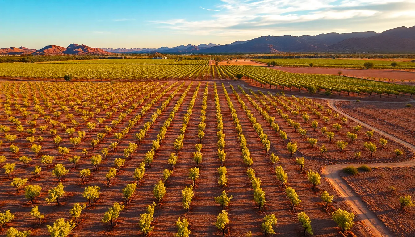
Arizona's Willcox AVA produces some of the country's most distinctive wines in one of its harshest growing environments. Intense heat, minimal rainfall, and UV radiation that would kill vines in softer climates create a unique terroir—but they also create management problems that traditional vineyard monitoring can't solve fast enough.
NDVI (Normalized Difference Vegetation Index) scanning from the air gives you what you need: a precise, data-driven map of vine stress across your entire property. Not guesswork. Not a walk-through at dawn. Actual numbers that tell you which blocks are struggling, where irrigation is failing, and where you're losing yield before harvest.
This is what the data actually shows you. And how you use it.
What NDVI Scanning Measures (and Why It Matters for Willcox Growers)
NDVI is a satellite and drone-based measurement that quantifies vegetation health by comparing how plants reflect red and near-infrared light. Healthy vines reflect more near-infrared light and absorb more red light. Stressed vines—whether from water deficit, pest pressure, or nutrient imbalance—reflect less near-infrared and more red. The sensor captures both wavelengths and calculates a single index value for every pixel in your vineyard.
The result is a color-coded map. Green and bright yellow zones show vigorous vines. Orange and red zones show stress. Blue or gray zones show dead or severely compromised plants.
For Willcox AVA growers, this matters because Willcox heat stress doesn't announce itself with visible wilting until damage is already done. By the time you see it walking the rows, you've lost days of irrigation response time and potential yield. NDVI data catches stress 5–10 days earlier, when intervention still works.
You get a baseline map early in the growing season (late May or early June), then repeat scans every 10–14 days through véraison. Each scan is georeferenced, meaning every pixel has GPS coordinates. You can zoom into a specific row, cross-reference it with your irrigation zones, and adjust water delivery block-by-block instead of field-wide.
How Willcox Growers Use the Data in Real Decisions
NDVI data isn't academic. It drives irrigation scheduling, nutrient decisions, and harvest timing—the three levers that determine yield and wine quality in the AVA.
Irrigation response. Willcox summers are dry. Most vineyards rely on drip irrigation, and emitter failure, soil variability, and heat-driven transpiration rates mean some blocks dry out faster than others. NDVI scanning reveals exactly which zones are water-stressed. Instead of irrigating the whole vineyard on a fixed schedule, you irrigate the stressed blocks more frequently and reduce water to vigorous zones. This saves water (critical in Arizona), prevents over-vigor in some blocks, and maintains consistent fruit quality across the property.
Nutrient and pest management. Stressed vines often show multiple problems at once: water deficit, nitrogen deficiency, and powdery mildew pressure all correlate with lower NDVI values. The scan alone doesn't tell you which problem is primary, but it tells you where to look. You can then scout those specific blocks for mites, mildew, or leaf chlorosis instead of walking 40 acres blindly. This focus saves spray costs and reduces unnecessary fungicide applications.
Harvest decisions. Willcox fruit develops fast in extreme heat. Growers often harvest in multiple passes to catch different ripeness levels across the vineyard. NDVI data from late August or early September shows which blocks are truly mature versus which are still pushing vigor. Blocks with lower NDVI values (stressed, smaller canopy) often have more concentrated fruit and may reach target Brix earlier. You can harvest those blocks first, then return to vigorous blocks when they catch up. This staged approach improves wine quality by matching harvest timing to actual fruit maturity, not calendar date.
The Practical Output: What You Actually Receive
When Stronghold Precision Aerials completes a vineyard NDVI scan, you receive:
Georeferenced NDVI raster map. A high-resolution color-coded image of your entire vineyard, with every pixel tagged with GPS coordinates. You can overlay it on your irrigation map, your soil map, or your harvest block boundaries. Most growers load this into their vineyard management software (Vinesmart, Winebook, or similar) to track changes over time.
CSV data export. Raw NDVI values for every zone, block, or management unit you've defined. If your vineyard is divided into 12 blocks, you get 12 rows of data: average NDVI, min/max, pixel count, and spatial statistics. This data feeds directly into your irrigation controller or your decision-making spreadsheet.
Thermal overlay (optional). If you request it, we also capture thermal imagery showing canopy temperature. In Willcox heat, canopy temperature correlates with water stress—cooler canopies indicate adequate water, hotter canopies indicate drought stress. Thermal + NDVI together give you redundant confirmation of water status.
Written summary. A brief report noting which blocks show stress, which show vigor, and which zones warrant immediate attention. No fluff. Just observation and recommendation.
The entire deliverable is yours to keep and use however you need. You own the data. You can share it with your vineyard manager, your agronomist, or your winemaker. You can compare year-to-year scans to track long-term vine health trends.
Timing: When to Scan During the Willcox Growing Season
Willcox's growing season runs roughly May through September. NDVI scanning is most useful during active vine growth and fruit development, not dormancy.
Early season (late May – early June). Baseline scan after bud break and initial shoot growth. This establishes your vineyard's vigor baseline and reveals any winter damage, replant issues, or soil variability that affects early-season growth. Use this scan to calibrate irrigation before peak heat arrives.
Mid-season (late June – mid-July). Flowering and early fruit set. NDVI at this stage shows which blocks are under stress during the critical flowering window. Stress during flowering reduces fruit set, so early detection allows you to adjust water and nutrition before damage compounds.
Late mid-season (late July – early August). Fruit development and véraison approach. This scan shows which blocks are tracking toward maturity and which are lagging. Use this data to plan harvest logistics and adjust final irrigation decisions.
Pre-harvest (late August – early September). Final scan before harvest. Shows mature versus immature blocks, helps you schedule multiple harvest passes, and gives you one last look at any pest or disease pressure before picking begins.
Most Willcox growers scan every 10–14 days during the growing season. That's typically 4–5 scans per year. Some years, if drought pressure is severe or pest pressure is high, they increase frequency to weekly scans for 2–3 weeks.
Cost and Turnaround
Stronghold Precision Aerials charges per-scan, not per-acre. A single NDVI scan of a Willcox vineyard (typically 40–120 acres) runs $400–$800 depending on block configuration and deliverable complexity. Thermal overlay adds $150–$250.
Turnaround is 3–5 business days from flight to final deliverable. Weather (wind, dust, cloud cover) can delay flights, but we maintain a flexible schedule to catch optimal conditions.
If you commit to a seasonal contract (4–5 scans over May–September), we offer a 15% discount on per-scan pricing. That brings a full season of NDVI monitoring to roughly $1,700–$3,400 for a typical Willcox property.
Compare that to the cost of a single irrigation miscalculation in Willcox heat—one week of over- or under-watering a 60-acre block can cost you $800–$1,200 in water, plus yield loss or fruit quality degradation worth thousands more. NDVI data pays for itself in the first irrigation adjustment.
Why Drone NDVI Beats Satellite or Ground-Based Monitoring
You might already subscribe to satellite NDVI data (Sentinel-2, Planet Labs, etc.). Satellite data is cheaper per image but has critical limitations in Willcox.
Satellite imagery refreshes every 5–10 days at best, and cloud cover in monsoon season (July–August) can wipe out 2–3 weeks of data. Drone scans give you on-demand coverage: if monsoon clouds clear on a Thursday afternoon, you fly Friday and have data by Monday. Satellite makes you wait for the next scheduled pass.
Satellite resolution is 3–10 meters per pixel. That's fine for detecting block-level stress but useless for identifying specific rows or irrigation zones within a block. Drone NDVI delivers 1-inch pixels, so you can see individual vine rows and pinpoint problem zones to within a few feet.
Ground-based monitoring (walking the vineyard, taking leaf samples, measuring soil moisture) is accurate but doesn't scale. You can scout 5–10 acres per day. A 60-acre vineyard takes two weeks to walk thoroughly. NDVI data covers the same 60 acres in 20 minutes of flight time.
Getting Started with Stronghold
If you're managing a Willcox AVA vineyard and you're tired of guessing at irrigation and harvest timing, NDVI scanning is the fastest way to move from reactive management to data-driven decisions.
Contact Stronghold Precision Aerials for a consultation. We'll discuss your vineyard layout, your current management challenges, and the scan frequency that makes sense for your operation. We'll schedule your first flight for optimal growing conditions and deliver data within days.
Our FAA-certified pilots specialize in vineyard NDVI scanning throughout the Willcox AVA and surrounding regions. We have the equipment and experience to capture the data you need and deliver it in formats your vineyard management software can use immediately.
Call now to schedule your first NDVI scan and see exactly what your vineyard is telling you about vine health, water status, and harvest readiness.
Ready to Get Aerial Services?
Stronghold Precision Aerials delivers professional drone services for agriculture, real estate, infrastructure, and more throughout Southern Arizona. Every project is handled with precision and attention to detail.
Contact SPA for a ConsultationMore from the Blog
How Drone Inspections Save Arizona Builders Time and Money
DronesUS Aerial integration: St. Pete Police Department launches Drone Hive
Officers now have a rooftop Drone Hive at their disposal, which allows them to use cutting-edge technology as additional first responders. The three drones, controlled by pilots inside SPPD’s new Real Time Intelligence Center (RTIC), can provide quicker response times for high-priority calls. On-
ConstructionHow Drones Are Transforming Construction Progress Monitoring in Southern Arizona
Discover how drone-based construction monitoring saves Arizona builders 50-70% on surveying costs. Learn about orthomosaic mapping, 3D modeling, and real-time progress documentation for your next project.
InspectionsDrone Roof Inspections in Arizona: Safer, Faster, and More Affordable
Discover how drone roof inspections save Arizona homeowners and businesses thousands on repairs. See thermal imaging benefits, cost comparison, and why insurers recommend UAV inspections.
AgricultureWhy Arizona Vineyards Need Drone NDVI Scanning
Discover how NDVI scanning helps viticulturists in the Willcox AVA detect water stress, optimize irrigation, and maximize yields in Arizona's unique wine country.
Real EstateAerial Photography for Real Estate: How Drones Sell Properties Faster
Discover why aerial drone photography is becoming essential for real estate marketing, including statistics on faster sales, higher prices, and how to build an effective drone package.
Industry GuideHow to Hire a Professional Drone Pilot in Arizona: What to Look For
Not all drone operators are created equal. Learn the 7 essential things to check before hiring a drone pilot for your next project in Southern Arizona.
Real EstateReal Estate Aerial Photography Pricing: What Agents and Sellers Should Know in 2026
How much does real estate aerial photography cost? A complete pricing breakdown for drone photography packages, what affects cost, and why aerial imagery delivers 3-15x ROI for property listings in Arizona.
ConstructionDrone Photography for Construction Sites: A Complete Guide to Aerial Documentation in Arizona
How construction companies in Arizona use drone photography for site documentation, stakeholder reporting, marketing, and safety compliance. Learn what to expect, what it costs, and how aerial imagery saves time and money on every project.