Real Estate Aerial Photography Pricing: What Agents and Sellers Should Know in 2026
How much does real estate aerial photography cost? A complete pricing breakdown for drone photography packages, what affects cost, and why aerial imagery delivers 3-15x ROI for property listings in Arizona.
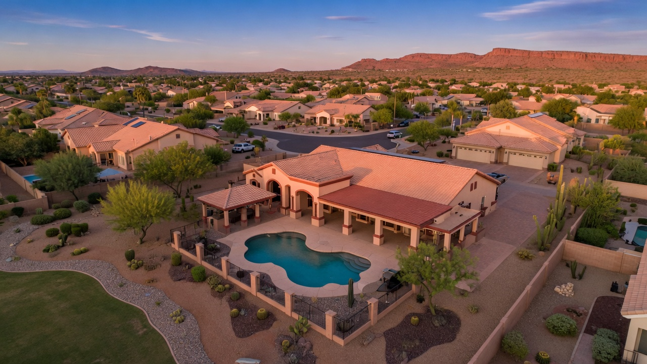
Real Estate Aerial Photography Pricing: A Complete Guide for Arizona Property Listings
You already know that great photos sell homes. But in 2026, the question isn't whether to include aerial photography in your listings—it's how to budget for it wisely and get maximum return from every dollar spent. Whether you're a listing agent trying to justify the expense to a seller or a homeowner weighing your marketing options, understanding real estate aerial photography pricing helps you make a smarter investment.
This guide breaks down exactly what drone photography costs for real estate in Arizona, what you get at each price point, and why the numbers consistently show that aerial imagery pays for itself many times over.
How Much Does Real Estate Drone Photography Cost?
Real estate aerial photography pricing varies based on property size, deliverables, and turnaround time. Here's what the market looks like across Arizona in 2026.
Standard Aerial Photo Package: $250–$500
A standard package typically includes 20 to 50 high-resolution aerial photographs captured from multiple altitudes and angles. This covers the property itself, the surrounding lot, and neighborhood context shots that show proximity to amenities, parks, or scenic features. Most providers deliver edited images within 48 to 72 hours.
This tier works well for single-family homes in suburban neighborhoods where the goal is to show lot size, landscaping, and neighborhood appeal. For many listings under $500,000, a standard aerial photo package is all you need to stand out from competing listings that rely solely on ground-level photography.
Premium Photo and Video Package: $500–$900
Premium packages add aerial video to the mix, typically a 60- to 90-second cinematic flyover of the property and surroundings. You'll also receive a larger photo set (50 to 100 images), often captured at golden hour for the best lighting. Some providers include basic video editing with music and title cards at this tier.
The addition of video is significant for online marketing. Listings with video receive 403% more inquiries than those without, according to the National Association of Realtors. For properties in the $500,000 to $1 million range, the premium tier is the sweet spot for maximizing exposure without overspending.
Luxury and Estate Package: $900–$2,000+
Luxury packages are designed for high-end properties where the marketing budget matches the listing price. These typically include extended cinematic video (2 to 4 minutes), 360-degree panoramic aerials, twilight photography, and priority 24-hour turnaround. Some packages also include interior drone shots for large open-concept homes or commercial spaces.
For properties above $1 million, this level of investment is standard. The cost is negligible relative to the listing price, and the marketing materials can be repurposed across multiple channels—MLS, social media, print brochures, and virtual tour platforms.
Specialized Property Packages: $400–$800
Rural acreage, ranches, and agricultural properties require a different approach. These packages focus on boundary documentation, terrain features, water sources, and access roads. Flights may cover a larger area and require more time in the air, which affects pricing. For land listings in Cochise County, Pinal County, or other rural Arizona areas, specialized packages ensure buyers can evaluate the full scope of what they're purchasing.
What Factors Affect Real Estate Drone Photography Pricing?
Not every shoot costs the same, and understanding the variables helps you budget accurately and avoid surprises.
Property Size and Acreage
A quarter-acre suburban lot takes less flight time and fewer batteries than a 40-acre ranch. Larger properties require more flight passes to capture complete coverage, which increases both the time on site and the post-production effort to deliver a cohesive set of images. Most providers base their pricing on property size tiers rather than flat rates.
Deliverable Complexity
Photos alone are the most affordable option. Adding video increases the price because it requires more skilled piloting, longer flight times, and significant post-production editing. Additional deliverables like 360-degree panoramas, virtual tours, or twilight sessions each add to the total because they require separate setups or return visits.
Turnaround Time
Standard turnaround is 48 to 72 hours for photos and up to a week for edited video. Rush delivery within 24 hours is available from most professional providers but comes with a premium, typically an additional 25% to 50%. If you're preparing for an open house weekend, plan your shoot early in the week to avoid rush fees.
Location and Travel
Providers in the Phoenix metro area typically include travel within a 30-mile radius in their base pricing. Properties in more remote areas of Arizona—Sedona, Prescott, Tucson's outskirts, or rural Southern Arizona—may incur travel fees ranging from $50 to $150 depending on distance. Booking multiple properties in the same area on the same day can reduce or eliminate these fees.
Airspace and FAA Requirements
Properties near airports, military bases, or in controlled airspace require the drone operator to obtain FAA authorization through the LAANC system before flying. While professional operators handle this routinely, shoots in heavily restricted airspace may require advance scheduling or altitude limitations that affect the final images. An experienced operator will flag these issues upfront during booking.
The ROI of Aerial Photography: Why the Numbers Make Sense
The conversation about pricing is incomplete without context about returns. Real estate aerial photography isn't a cost—it's an investment with measurable outcomes.
Faster Sales Reduce Carrying Costs
Properties with aerial imagery sell 15% to 20% faster than listings with ground-level photos only. For a seller paying a $2,500 monthly mortgage, shaving even two weeks off the time to sale saves over $1,200 in carrying costs alone. Factor in property taxes, insurance, HOA fees, and maintenance, and a $400 drone photography package that accelerates the sale pays for itself before the photographer leaves the property.
Higher Listing Prices Hold Firm
Listings with professional aerial imagery command 5% to 15% higher final sale prices compared to similar properties marketed with standard photography. On a $400,000 home, even a 5% premium represents $20,000 in additional value. The photography investment of a few hundred dollars is a rounding error against that return.
More Buyer Inquiries Mean Better Offers
Aerial photography generates up to three times more buyer inquiries per listing. More interest doesn't just mean a faster sale—it means competitive offers. Multiple interested buyers create leverage for the seller to negotiate above asking price, waive contingencies, or secure more favorable closing terms.
Agent Competitive Advantage
For listing agents, offering drone photography as a standard part of your marketing package differentiates you from competitors in listing presentations. Sellers choose agents who demonstrate a commitment to maximizing their property's exposure. The $300 to $500 investment in aerial photos is a fraction of what most agents spend on other marketing that delivers far less measurable impact.
What to Look for in a Real Estate Drone Photography Provider
Price matters, but the cheapest option isn't always the best value. Here's what separates professional real estate drone operators from hobbyists with cameras.
FAA Part 107 Certification
Any drone operator flying commercially must hold a current FAA Part 107 Remote Pilot Certificate. This isn't optional—it's federal law. Operating without certification exposes both the operator and the property owner to liability. Always ask to see the operator's certificate before booking.
Insurance Coverage
Professional operators carry drone-specific liability insurance, typically $1 million or more per occurrence. This protects you, the property, and neighbors in the unlikely event of an incident during the shoot. Ask for a certificate of insurance—reputable operators provide one without hesitation.
Real Estate Portfolio and Experience
Flying a drone and photographing real estate are two different skills. Look for a provider whose portfolio demonstrates an understanding of composition, lighting, and property presentation—not just technical flying ability. The best operators know which angles sell homes and which altitudes reveal a property's best features.
Post-Production Quality
Raw drone photos rarely look listing-ready. Professional post-production includes color correction, exposure balancing, horizon leveling, and lens distortion correction. Ask about the editing process and review sample before-and-after images to gauge the quality of finished deliverables.
When to Schedule Your Real Estate Drone Photography
Timing your drone photography session correctly makes a significant difference in the quality of your final images and the effectiveness of your listing.
Best Time of Day
The golden hours—the first hour after sunrise and the last hour before sunset—produce the warmest, most flattering light for aerial photography. Midday shoots in Arizona's intense sun create harsh shadows and washed-out colors. If your schedule allows it, early morning or late afternoon sessions deliver noticeably better results at no additional cost.
Best Time of Year in Arizona
Arizona's real estate photography season runs year-round, but each season has advantages. Fall through spring (October to April) offers comfortable temperatures and clearer skies. Summer shoots are possible but may need to start at sunrise to avoid heat shimmer and thermal turbulence that affects image sharpness at altitude. The monsoon season (July to September) brings dramatic cloud formations that can create stunning backdrops when the timing works out.
Before or After Staging
Schedule your aerial photography after landscaping, pool cleaning, and exterior staging are complete. Aerial views reveal every detail—dead patches in the lawn, a cluttered patio, or a pool that needs cleaning are all visible from above. Coordinate with your staging team so the property looks its best from every angle, including straight down.
Stronghold Precision Aerials: Real Estate Photography Built for Arizona
We specialize in aerial photography for Arizona real estate, from suburban homes in Mesa and Gilbert to rural properties across Cochise and Pinal counties. Every shoot is planned around your property's unique features, with attention to the angles, altitudes, and lighting conditions that present it in the best possible way.
Our real estate packages include high-resolution aerial stills, optional cinematic video, and professional post-production—all delivered on a timeline that fits your listing schedule. We're FAA Part 107 certified, fully insured, and we've photographed properties ranging from starter homes to multi-million-dollar estates across Southern Arizona.
Ready to See What Your Listing Looks Like from Above?
Contact Stronghold Precision Aerials for a free quote tailored to your property. We'll recommend the right package for your listing price point and marketing goals, and we'll have your images ready before your listing goes live.
Ready to Get Aerial Services?
Stronghold Precision Aerials delivers professional drone services for agriculture, real estate, infrastructure, and more throughout Southern Arizona. Every project is handled with precision and attention to detail.
Contact SPA for a ConsultationMore from the Blog
Vineyard NDVI Scanning in Willcox AVA: What Growers Actually See in the Data
DronesHow Drone Inspections Save Arizona Builders Time and Money
DronesUS Aerial integration: St. Pete Police Department launches Drone Hive
Officers now have a rooftop Drone Hive at their disposal, which allows them to use cutting-edge technology as additional first responders. The three drones, controlled by pilots inside SPPD’s new Real Time Intelligence Center (RTIC), can provide quicker response times for high-priority calls. On-
ConstructionHow Drones Are Transforming Construction Progress Monitoring in Southern Arizona
Discover how drone-based construction monitoring saves Arizona builders 50-70% on surveying costs. Learn about orthomosaic mapping, 3D modeling, and real-time progress documentation for your next project.
InspectionsDrone Roof Inspections in Arizona: Safer, Faster, and More Affordable
Discover how drone roof inspections save Arizona homeowners and businesses thousands on repairs. See thermal imaging benefits, cost comparison, and why insurers recommend UAV inspections.
AgricultureWhy Arizona Vineyards Need Drone NDVI Scanning
Discover how NDVI scanning helps viticulturists in the Willcox AVA detect water stress, optimize irrigation, and maximize yields in Arizona's unique wine country.
Real EstateAerial Photography for Real Estate: How Drones Sell Properties Faster
Discover why aerial drone photography is becoming essential for real estate marketing, including statistics on faster sales, higher prices, and how to build an effective drone package.
Industry GuideHow to Hire a Professional Drone Pilot in Arizona: What to Look For
Not all drone operators are created equal. Learn the 7 essential things to check before hiring a drone pilot for your next project in Southern Arizona.
ConstructionDrone Photography for Construction Sites: A Complete Guide to Aerial Documentation in Arizona
How construction companies in Arizona use drone photography for site documentation, stakeholder reporting, marketing, and safety compliance. Learn what to expect, what it costs, and how aerial imagery saves time and money on every project.