Drone Photography for Construction Sites: A Complete Guide to Aerial Documentation in Arizona
How construction companies in Arizona use drone photography for site documentation, stakeholder reporting, marketing, and safety compliance. Learn what to expect, what it costs, and how aerial imagery saves time and money on every project.
Why Construction Companies Are Making Drone Photography Standard Practice
Every construction project tells a story—from the first ground-clearing to the final punch list. The challenge has always been telling that story accurately, efficiently, and in a way that keeps everyone from investors to inspectors aligned on what's actually happening on the ground. Traditional methods of documenting construction sites involve a person walking the perimeter with a camera, climbing scaffolding for elevated shots, or renting boom lifts for a broader perspective. All of these take time, create safety risks, and still deliver an incomplete picture.
Drone photography changes the equation entirely. A single 30-minute flight captures what would take a ground crew half a day to document, from angles that are physically impossible to reach any other way. For construction companies across Mesa, Gilbert, Chandler, and greater Phoenix, drone photography has moved from a nice-to-have novelty to a practical tool that reduces costs, prevents disputes, and delivers better outcomes on every project.
What Construction Drone Photography Actually Delivers
Drone photography for construction sites goes well beyond basic aerial snapshots. Understanding the full range of deliverables helps you decide what level of service fits your project's needs and budget.
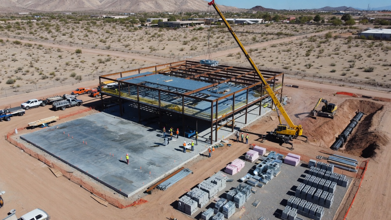
High-Resolution Aerial Stills
Modern commercial drones capture images at 20 megapixels or higher, producing photographs with enough detail to identify individual materials, equipment positions, and work progress from several hundred feet in the air. A single aerial photograph of a construction site can show the entire footprint in context—the building pad relative to adjacent properties, staging areas, access roads, material storage, and perimeter conditions all visible in one frame.
These images serve multiple purposes: progress reports for owners and lenders, pre-pour documentation for concrete work, as-built verification against plans, and marketing material for developers who want to showcase active projects to prospective buyers or tenants.
Aerial Video Walkthroughs
Video captures what still photography cannot: the spatial relationships between different areas of a site, the flow of access routes, and the scale of work completed. A 2- to 3-minute aerial video flyover gives remote stakeholders the feeling of actually visiting the site without the travel time, safety training, or PPE requirements of an in-person visit.
For general contractors managing relationships with out-of-state owners or institutional investors, monthly aerial video updates reduce the number of in-person site visits required while keeping stakeholders more informed than traditional photo reports ever could.
Time-Lapse Compilation
When a drone operator returns to the same site on a regular schedule—weekly or monthly—the resulting images can be compiled into a time-lapse sequence that shows the entire build from start to finish. This isn't just visually impressive. Time-lapse compilations are used by developers for marketing upcoming projects, by general contractors for portfolio development, and by project managers to analyze the actual pace of construction against scheduled milestones.
Thermal and Inspection Imagery
Drones equipped with thermal cameras detect heat signatures that reveal issues invisible to the naked eye. On construction sites, thermal imaging identifies moisture intrusion in freshly sealed building envelopes, locates HVAC ductwork for verification against mechanical plans, confirms insulation coverage before drywall closes up wall cavities, and spots electrical hot spots in panel installations. Catching these issues during construction costs a fraction of what remediation costs after occupancy.
Six Ways Construction Companies Use Drone Photography
The value of aerial construction documentation extends across nearly every phase and function of a building project. Here's how teams are putting drone imagery to work in practice.
1. Pre-Construction Site Assessment
Before breaking ground, aerial photography establishes baseline conditions of the site and surrounding area. This documentation proves invaluable when neighbors claim construction damaged their property, when environmental conditions need to be recorded before disturbance, or when existing utility infrastructure needs to be mapped for connection planning. A thorough aerial survey of the site and its context before work begins costs a few hundred dollars and can prevent disputes worth thousands.
2. Progress Documentation for Lender Draws
Construction lenders release funds in scheduled draws based on verified completion of specific milestones. Aerial photography provides clear, objective documentation of progress that supports draw requests and reduces back-and-forth between the contractor, owner, and lender's inspector. An overhead photograph showing completed framing, mechanical rough-in, or roof installation is harder to dispute than a written percentage-complete estimate.
3. Safety and Compliance Monitoring
Aerial imagery reveals safety conditions across the entire site simultaneously, which is something no ground-level walkthrough can achieve. Project managers and safety officers use drone photographs to identify fall protection gaps, verify barricade placement, confirm proper material storage, and document housekeeping conditions. In Arizona, where OSHA's heat illness prevention focus adds another layer of compliance requirements, documenting shade structures, water stations, and rest area conditions from the air provides evidence of compliance that ground-level photos miss.
4. Stakeholder Communication and Reporting
Weekly or monthly aerial photographs transform project reporting from abstract descriptions into visual narratives. When a project manager tells an owner that steel erection is 60% complete, that statement carries significantly more weight when accompanied by an aerial photograph clearly showing the erected structure against the full building footprint. This level of transparency builds trust, reduces unnecessary site visits, and keeps decision-makers engaged without requiring them to interpret technical construction language.
5. Marketing and Business Development
Developers use aerial construction photography to market projects before completion. Showing prospective buyers or tenants that a project is actively progressing—with dramatic aerial imagery of the rising structure—creates urgency and confidence that ground-level construction fence photos never achieve. For general contractors, a portfolio of aerial construction photography demonstrates capability and professionalism in proposals for future work.
6. Dispute Resolution and Claims Documentation
Construction disputes over schedule, scope, and site conditions are common. Regular aerial documentation creates an objective timeline of exactly what happened and when. If a subcontractor claims they couldn't access their work area, an aerial photograph from that date shows whether the area was clear. If weather delays are disputed, aerial documentation shows site conditions on specific dates. This evidence is dramatically more persuasive in mediation or litigation than competing verbal accounts.
What Construction Drone Photography Costs in Arizona
Pricing for construction site drone photography depends on the scope of services, frequency, and project duration. Here's what to expect.
Single-Visit Documentation: $300–$600
A single site visit produces a comprehensive set of 30 to 75 aerial photographs covering the full site from multiple altitudes and angles, plus a short aerial video flyover. This is appropriate for milestone documentation, pre-construction baselines, or one-time project records. Turnaround is typically 24 to 48 hours for edited images.
Monthly Progress Documentation: $250–$450 per Visit
Recurring monthly visits at a reduced per-visit rate. The drone operator follows a consistent flight path each visit, producing directly comparable imagery that shows progress over time. Monthly packages typically include a photo set, short video, and a compiled comparison of current versus previous visits. For a 12-month project, monthly documentation runs $3,000 to $5,400 total.
Weekly Documentation: $200–$350 per Visit
High-frequency documentation for fast-track projects, phased construction, or projects where lender or owner requirements demand weekly updates. Weekly visits offer the best per-visit rate and produce the most detailed construction timeline. A 6-month project with weekly documentation runs $5,200 to $9,100 total—still a fraction of the cost of a single schedule dispute or failed lender inspection.
Comprehensive Project Packages: Custom Pricing
Large-scale or long-duration projects benefit from comprehensive packages that bundle aerial photography with thermal imaging, time-lapse compilation, and specialized deliverables like orthomosaic maps or volumetric measurements. These are quoted on a project basis after understanding the full scope of documentation needs.
Arizona-Specific Considerations for Construction Drone Photography
Construction drone photography in Arizona requires understanding the state's unique environmental and regulatory landscape.
Heat and Flight Conditions
Arizona summers push both equipment and operators to their limits. Drone batteries lose capacity in extreme heat, reducing available flight time per battery by 15% to 25% when temperatures exceed 110°F. Professional operators plan summer flights for early morning—often starting at sunrise—to capture images in cooler conditions with better lighting. This scheduling consideration doesn't affect image quality, but it does mean that summer flights need to be planned further in advance to secure early-morning time slots.
Dust and Monsoon Conditions
Arizona's monsoon season from July through September brings sudden dust storms, microbursts, and heavy rain that can shut down drone operations with little notice. Professional operators monitor weather conditions closely and build flexibility into scheduling during monsoon months. The upside is that post-storm documentation captures site drainage patterns, erosion issues, and storm damage that inform construction decisions and insurance claims.
Military and Airport Airspace
Much of the Phoenix metropolitan area sits within controlled airspace due to Phoenix Sky Harbor, Mesa Gateway, Scottsdale Airport, and Luke Air Force Base. Construction sites in these areas require the drone operator to obtain FAA authorization through the LAANC system before each flight. Professional operators with established LAANC access handle this routinely, but it's worth confirming your provider's experience with controlled airspace operations if your project is in central Mesa, Chandler, Scottsdale, or near any airport.
Maricopa County Dust Control Compliance
Maricopa County's dust control regulations require construction sites to implement and document specific dust mitigation measures. Aerial photography provides compelling documentation of water truck coverage, stabilized access roads, and perimeter conditions that support compliance records during county inspections. An aerial photograph showing proper dust control across the full site is more comprehensive than any ground-level walkthrough report.
How to Get Started with Construction Drone Photography
Adding aerial documentation to your construction project is straightforward, but a few steps early in the process ensure you get maximum value.
Start Before You Break Ground
The most valuable drone photographs on any construction project are often the ones taken before work begins. Pre-construction baseline imagery establishes existing conditions of the site, adjacent properties, roads, and utilities. Schedule your first flight before any equipment arrives on site.
Establish a Consistent Schedule
Regular documentation at consistent intervals—weekly or monthly—produces the most useful project record. Work with your drone photography provider to set a recurring schedule that aligns with your reporting cycles and milestone dates. Consistency in timing and flight paths makes progress comparison effortless.
Integrate with Your Project Management Workflow
Drone imagery is most valuable when it's accessible to everyone who needs it. Discuss delivery format and timing with your provider so images arrive in time for owner meetings, lender inspections, or progress reports. Most professional operators deliver images through cloud-based platforms that allow your entire team to access, download, and share images without email attachment limitations.
Stronghold Precision Aerials: Construction Photography Across Arizona
We work with general contractors, developers, and construction managers across the Phoenix metro area and Southern Arizona. From single-visit milestone documentation to year-long weekly progress packages, we tailor our services to fit your project's scope, schedule, and budget.
Every flight is conducted by FAA Part 107 certified pilots with construction industry experience. We understand the difference between a pretty aerial photograph and documentation that actually serves your project's needs—from lender draw support to dispute-ready evidence. Our images are delivered on time, every time, with the consistency and quality your project demands.
Get a Quote for Your Construction Project
Tell us about your project—location, duration, and documentation needs—and we'll put together a package that covers what matters most to your team and your stakeholders.
Ready to Get Aerial Services?
Stronghold Precision Aerials delivers professional drone services for agriculture, real estate, infrastructure, and more throughout Southern Arizona. Every project is handled with precision and attention to detail.
Contact SPA for a ConsultationMore from the Blog
Vineyard NDVI Scanning in Willcox AVA: What Growers Actually See in the Data
DronesHow Drone Inspections Save Arizona Builders Time and Money
DronesUS Aerial integration: St. Pete Police Department launches Drone Hive
Officers now have a rooftop Drone Hive at their disposal, which allows them to use cutting-edge technology as additional first responders. The three drones, controlled by pilots inside SPPD’s new Real Time Intelligence Center (RTIC), can provide quicker response times for high-priority calls. On-
ConstructionHow Drones Are Transforming Construction Progress Monitoring in Southern Arizona
Discover how drone-based construction monitoring saves Arizona builders 50-70% on surveying costs. Learn about orthomosaic mapping, 3D modeling, and real-time progress documentation for your next project.
InspectionsDrone Roof Inspections in Arizona: Safer, Faster, and More Affordable
Discover how drone roof inspections save Arizona homeowners and businesses thousands on repairs. See thermal imaging benefits, cost comparison, and why insurers recommend UAV inspections.
AgricultureWhy Arizona Vineyards Need Drone NDVI Scanning
Discover how NDVI scanning helps viticulturists in the Willcox AVA detect water stress, optimize irrigation, and maximize yields in Arizona's unique wine country.
Real EstateAerial Photography for Real Estate: How Drones Sell Properties Faster
Discover why aerial drone photography is becoming essential for real estate marketing, including statistics on faster sales, higher prices, and how to build an effective drone package.
Industry GuideHow to Hire a Professional Drone Pilot in Arizona: What to Look For
Not all drone operators are created equal. Learn the 7 essential things to check before hiring a drone pilot for your next project in Southern Arizona.
Real EstateReal Estate Aerial Photography Pricing: What Agents and Sellers Should Know in 2026
How much does real estate aerial photography cost? A complete pricing breakdown for drone photography packages, what affects cost, and why aerial imagery delivers 3-15x ROI for property listings in Arizona.