How Drones Are Transforming Construction Progress Monitoring in Southern Arizona
Discover how drone-based construction monitoring saves Arizona builders 50-70% on surveying costs. Learn about orthomosaic mapping, 3D modeling, and real-time progress documentation for your next project.
Drone Construction Monitoring: The Competitive Edge Arizona Builders Need
Construction projects across Southern Arizona face a unique set of challenges: extreme heat limits the hours workers can safely spend on-site, monsoon season disrupts schedules, and the sheer scale of desert development projects makes traditional surveying impractical. For general contractors, project managers, and developers operating in this environment, drone-based construction monitoring has moved from a novelty to a necessity.
Professional drone services now deliver what used to take survey crews weeks in just hours—high-resolution orthomosaic maps, volumetric measurements, 3D site models, and timestamped progress documentation that keeps projects on schedule and stakeholders informed. Here's how this technology works, what it delivers, and why it's transforming the way Arizona builds.
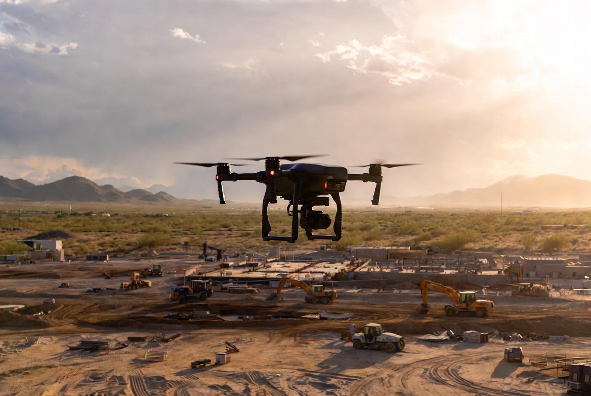
What Is Drone Construction Monitoring?
Drone construction monitoring uses unmanned aerial vehicles equipped with high-resolution cameras and specialized sensors to capture detailed aerial imagery of a construction site at regular intervals. This imagery is then processed through photogrammetry software to generate precise maps, measurements, and 3D models that document exactly what's happening on the ground.
Unlike a simple aerial photograph, drone monitoring produces survey-grade data. Each image is geotagged with GPS coordinates, and the overlapping imagery (typically 75% frontal overlap and 60% side overlap) allows processing software to stitch together centimeter-accurate representations of the entire site.
Key Deliverables from Drone Monitoring Flights
A professional drone monitoring session produces several critical deliverables that serve different stakeholders and purposes:
- Orthomosaic maps: Georeferenced, distortion-corrected aerial maps that provide a true top-down view of the entire site. These maps are accurate to within 1-3 centimeters and can be overlaid on design plans to verify construction matches specifications
- 3D point clouds: Dense three-dimensional representations of the site created from millions of individual measurement points. Point clouds enable precise volumetric calculations for earthwork, stockpile measurements, and grading verification
- 3D mesh models: Textured three-dimensional models that provide a realistic visual representation of the site from any angle. These are invaluable for stakeholder presentations and virtual site walks
- Digital elevation models (DEMs): Detailed topographic maps showing elevation changes across the site, critical for drainage planning and grading verification
- Progress comparison reports: Side-by-side comparisons of the site at different dates, clearly showing what work has been completed between monitoring flights

Why Traditional Surveying Falls Short in Arizona
Traditional ground-based surveying has been the construction industry's standard for decades, but in Arizona's environment, its limitations become acute.
Heat and Safety Constraints
When ground temperatures exceed 150 degrees Fahrenheit on exposed construction sites during Arizona summers, survey crews face dangerous working conditions. OSHA heat illness prevention guidelines limit continuous outdoor exposure, which means traditional surveys that might take a full day elsewhere can stretch across multiple days in Southern Arizona. Each additional day adds cost and delays schedule verification.
Time and Coverage Limitations
A traditional survey crew covers approximately 5 acres per hour on foot. For large-scale Arizona developments—solar farms, master-planned communities, highway projects—a complete site survey can take weeks. A professional drone covers 120 acres per hour, delivering the same survey-grade accuracy in a fraction of the time. What once required a two-week ground survey can be completed in a single morning flight.
Frequency and Cost
Because traditional surveys are expensive and time-consuming, most projects only survey at critical milestones. This creates blind spots between surveys where problems can develop undetected. Drone monitoring is cost-effective enough to perform weekly or bi-weekly, catching issues like drainage problems, grading errors, or schedule delays before they become expensive to fix.
Real Cost Savings: What the Numbers Show
The financial case for drone construction monitoring is compelling, and the data from industry studies backs it up.
Surveying cost reduction: Drone-based site surveys cost 50-70% less than traditional ground surveys for equivalent accuracy. For a project that budgets $50,000 annually for surveying, that's $25,000-$35,000 in direct savings.
Labor efficiency: Projects using regular drone monitoring report 20-30% reductions in labor costs related to rework and schedule delays. When problems are caught within days instead of weeks, the cost to correct them drops dramatically.
Schedule adherence: Real-time progress documentation helps project managers identify schedule slippage early. Industry data shows that projects using weekly drone monitoring experience 15-25% fewer schedule overruns compared to those relying on traditional milestone-based reporting.
Dispute resolution: Timestamped, georeferenced documentation provides indisputable evidence of site conditions at any point in the project. This reduces disputes between contractors, subcontractors, and owners—and when disputes do arise, resolution is faster and cheaper because the data is objective.
Research from industry sources indicates that 92% of construction firms implementing drone programs achieve positive ROI within the first year, with typical payback periods of 3-6 months.
Arizona-Specific Applications
Southern Arizona's construction landscape creates several specialized applications where drone monitoring provides outsized value.
Solar Farm Development
Arizona's exceptional solar irradiance makes it one of the top states for utility-scale and commercial solar installations. Drone monitoring is particularly valuable for solar projects because it enables precise panel alignment verification across hundreds of acres, thermal imaging to detect faulty panels and wiring issues during commissioning, terrain mapping for optimal racking placement, and ongoing vegetation management monitoring around ground-mounted arrays.
For the large solar developments in Pinal and Maricopa counties, drone monitoring has become standard practice during both construction and the operational phase.
Monsoon Season Documentation
Arizona's monsoon season (June 15 through September 30) brings sudden, intense storms that can dramatically alter a construction site overnight. Flash flooding rearranges grading work, wind damages temporary structures, and water saturation compromises foundations. Drone flights immediately after major storm events provide rapid damage assessment and documentation for insurance claims, precise measurement of erosion and sediment displacement, verification of drainage system performance, and evidence for weather-related delay claims.
Having pre-storm and post-storm drone data creates an indisputable timeline that protects all parties when weather impacts project schedules and budgets.
Master-Planned Community Development
Southern Arizona continues to see significant residential development, with master-planned communities spanning hundreds or thousands of acres. For developers managing multiple phases, lots, and subcontractors simultaneously, drone monitoring provides a single source of truth for the entire project. Regular flights document infrastructure installation across all phases, verify lot grading and drainage compliance, track road and utility construction progress, and generate marketing materials showing community development.

The Monitoring Process: What to Expect
When you engage a professional drone monitoring service for your construction project, here's the typical workflow:
Pre-Flight Planning
Before the first flight, the drone team reviews your site plans, identifies the monitoring area boundaries, and establishes ground control points (GCPs) for survey-grade accuracy. GCPs are physical markers placed on the site with precisely known GPS coordinates—they serve as calibration points that ensure the drone data matches real-world positions within 1-3 centimeters.
Automated Flight Execution
Using pre-programmed flight plans, the drone flies systematic grid patterns over the entire site at a consistent altitude (typically 200-400 feet AGL depending on the resolution needed). The flight is largely automated, ensuring consistent coverage and overlap on every mission. A typical 50-acre site requires approximately 25-30 minutes of flight time.
Data Processing
After the flight, imagery is uploaded to professional processing platforms like DroneDeploy or Pix4D. These platforms stitch the overlapping images into orthomosaics, generate point clouds, and build 3D models. Processing typically completes within 1-3 hours for cloud-based platforms, meaning same-day delivery of results is standard.
Reporting and Analysis
The processed data is compiled into a monitoring report that includes the current orthomosaic overlaid on site plans, volumetric calculations (cut/fill analysis for earthwork), progress comparisons against previous flights, and annotations highlighting specific areas of concern or notable progress. Reports are delivered digitally and can be shared with all project stakeholders through secure cloud-based platforms.
Integrating Drone Data with Project Management
Modern drone monitoring platforms integrate directly with the construction management tools your team already uses. DroneDeploy connects with Procore and Autodesk Construction Cloud, allowing drone data to flow directly into your existing project management workflows. This integration means progress photos appear alongside daily logs, volumetric data feeds into quantity tracking, orthomosaics overlay on BIM models for design-versus-built comparison, and historical flight data is archived with project documentation.
This integration eliminates the data silos that often plague construction projects, where survey data lives in one system, progress photos in another, and schedule updates in a third.
Regulatory Compliance for Construction Drone Operations
Commercial drone operations on construction sites in Arizona must comply with FAA regulations under Part 107. Professional drone service providers handle all regulatory requirements, but it's helpful for project managers to understand the basics:
- Part 107 certification: All commercial drone pilots must hold a current FAA Remote Pilot Certificate
- Remote ID compliance: All commercial drones must broadcast Remote ID information during flight, as required since 2023
- Altitude limits: Operations are limited to 400 feet above ground level unless a waiver is obtained
- Airspace authorization: Sites near airports may require FAA airspace authorization through the LAANC system
- Liability insurance: Professional operators carry $1 million or more in liability coverage for construction site operations
- Site coordination: Flights must be coordinated with site management to ensure worker safety and avoid conflicts with crane operations or other aerial activities
When selecting a drone monitoring provider, verify their Part 107 certification, insurance coverage, and experience operating on active construction sites. Professional providers like Stronghold Precision Aerials maintain all required certifications and carry comprehensive insurance specifically for construction monitoring operations.
Getting Started with Drone Monitoring for Your Project
Whether you're breaking ground on a new development, managing an active construction site, or overseeing a solar installation, drone monitoring delivers measurable value from the first flight. The combination of lower surveying costs, faster data delivery, and comprehensive documentation makes it one of the highest-ROI technology investments available to Arizona's construction industry.
Stronghold Precision Aerials provides professional drone construction monitoring throughout Southern Arizona. Our FAA-certified pilots specialize in photogrammetry, 3D modeling, and construction documentation for projects of all sizes. Contact us to discuss how drone monitoring can improve efficiency and reduce costs on your next project.
Ready to Get Aerial Services?
Stronghold Precision Aerials delivers professional drone services for agriculture, real estate, infrastructure, and more throughout Southern Arizona. Every project is handled with precision and attention to detail.
Contact SPA for a ConsultationMore from the Blog
Vineyard NDVI Scanning in Willcox AVA: What Growers Actually See in the Data
DronesHow Drone Inspections Save Arizona Builders Time and Money
DronesUS Aerial integration: St. Pete Police Department launches Drone Hive
Officers now have a rooftop Drone Hive at their disposal, which allows them to use cutting-edge technology as additional first responders. The three drones, controlled by pilots inside SPPD’s new Real Time Intelligence Center (RTIC), can provide quicker response times for high-priority calls. On-
InspectionsDrone Roof Inspections in Arizona: Safer, Faster, and More Affordable
Discover how drone roof inspections save Arizona homeowners and businesses thousands on repairs. See thermal imaging benefits, cost comparison, and why insurers recommend UAV inspections.
AgricultureWhy Arizona Vineyards Need Drone NDVI Scanning
Discover how NDVI scanning helps viticulturists in the Willcox AVA detect water stress, optimize irrigation, and maximize yields in Arizona's unique wine country.
Real EstateAerial Photography for Real Estate: How Drones Sell Properties Faster
Discover why aerial drone photography is becoming essential for real estate marketing, including statistics on faster sales, higher prices, and how to build an effective drone package.
Industry GuideHow to Hire a Professional Drone Pilot in Arizona: What to Look For
Not all drone operators are created equal. Learn the 7 essential things to check before hiring a drone pilot for your next project in Southern Arizona.
Real EstateReal Estate Aerial Photography Pricing: What Agents and Sellers Should Know in 2026
How much does real estate aerial photography cost? A complete pricing breakdown for drone photography packages, what affects cost, and why aerial imagery delivers 3-15x ROI for property listings in Arizona.
ConstructionDrone Photography for Construction Sites: A Complete Guide to Aerial Documentation in Arizona
How construction companies in Arizona use drone photography for site documentation, stakeholder reporting, marketing, and safety compliance. Learn what to expect, what it costs, and how aerial imagery saves time and money on every project.